|
|
BMe Research Grant |
|

Pál Vásárhelyi Doctoral School of Civil Engineering and Earth Sciences
Department of Hydraulic and Water Resources Engineering
Supervisor: Dr. Baranya Sándor
Investigation of the Hydraulic and Ecologic Effects of Vessel Induced Waves
Introducing the research area
The research focuses on the hydrodynamic effects of ship induced waves on the river banks, and as a consequence, on its impact on the riverine fauna. Ship induced waves may have harmful effects on macroscopic creatures living on the river substrate, e.g. macroscopic crabs or fish eggs. The joint research of hydraulic engineers and ecologists, i.e. ecohydraulics, is a quite young, yet quickly developing interdisciplinary field of science, where the strong cooperation of the different disciplines is required.
Brief introduction of the research place
The theoretical, technical and financial background of the research is provided by the Department of Hydraulic and Water Resources Engineering of BME. The institute is equipped with state-of-the-art infrastructure necessary to investigate the hydrodynamic effects of ship induced waves. Moreover, the supercomputer of the university (Superman) provides a significant computational resource to perform numerical simulations of the related phenomena.
History and context of the research
Inland navigation is clearly one of the most environment-friendly manners of transportation; however, it can also have negative effects. The direct contact with ship propellers may cause mechanical damages to aquatic animals [1], while oil and fuel contaminations may affect water quality [2]. The negative effects of ship induced waves on benthic creatures have been realized by the biologist and ecologist community, however, the quantitative evaluation of the phenomenon (e.g. number of individuals detached from the substrate as a function of hydrodynamic parameters) has barely been investigated yet (e.g. [3-5]).
Local increase of near-bed velocities due to vessel generated waves may detach and drift creatures living at the river bed (macroinvertebrates, juvenile fish, fish eggs, etc.) to areas where their chances of survival are close to zero (e.g. areas of high flow velocities or the river bank). The resuspension of fine sediments in shallower areas can also affect the hunting success of visually oriented fishes; moreover, increased turbidity reduces the availability of light for the growth of phytoplankton and biofilms as well.
The interactions between these biotic and abiotic parameters emphasize the necessity of strong collaborations between the experts of the different disciplines. The establishment of such cooperation is under progress among BME, the Danube Research Institute of the Hungarian Academy of Sciences and the Duna-Ipoly National Park Directorate.
The evaluation, protection and improvement of surface water ecosystems is a key field of research today, which can be well illustrated by considering the objectives of the EU Water Framework Directive or the currently forming National Water Research Program of the Hungarian Academy of Sciences.
Aims of the research
The aim of the research, on one hand, is to develop a methodology for the investigation of hydro- and morphodynamic effects of ship induced waves based on field measurements, data processing and computational methods. On the other hand, through understanding the hydrodynamic nature of these phenomena, it is expected to get a step closer to their ecologic consequences as well.
From the engineering point of view, the basic question is what sort of devices and methods can be utilized to quantitatively assess different physical parameters related to vessel induced waves. The host department possesses the necessary flow velocity and pressure measuring devices which ensure the direct field measurement of the most relevant hydrodynamic parameters over time. The main task is, therefore, the proper post-processing of the collected time series of high temporal resolution in order to assess and classify the effects of ship waves from different aspects, which can potentially support the exploration of relationships between biotic and abiotic features.
Furthermore, all field measurements support the set-up, parameterization and validation of computational models, providing a suitable tool to perform detailed assessment of conditions which cannot be measured (e.g. past or future states). It is important to know what sort of computational tools could be employed for the investigation of a specific phenomenon and to be aware of the limitations and shortcomings of such software. The open-source numerical tool REEF3D [6] was tested in herein study for the discrete solution of the complex flow features related to ship induced waves (e.g. simulation of wave breaking and sediment resuspension).
Methods
The most important pillar of this research is the field wave measurements. During such field campaigns, wave measurements are conducted from the bank for a whole day. Pressure gauges of high temporal resolution (8-16 Hz) are deployed to assess the hydrodynamic effects of vessel generated waves in the near-bank region. Discrete Fourier-transformation of the pressure time series provides the opportunity to reveal the irregular nature of these complex wave events; moreover, the temporal variation of different wave parameters (e.g. wave height, wave period) can also be derived. The pressure measurements also provide adequate boundary conditions for numerical hydrodynamic modeling.
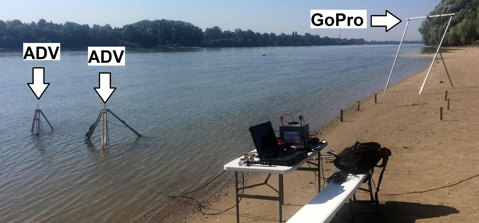
Figure 1. Field measurement setup
Three-dimensional, single-point velocities of high temporal resolution (8-25 Hz) are measured with acoustic Doppler velocimeters (ADV). Such measurements may directly be used to draw ecohydraulic conclusions: e.g. if the measured velocities permanently exceed the so called burst swimming capabilities of local fishes, then their drifting can be expected. Knowing the temporal variation of near-bed velocities and other characteristic wave parameters, the value of the bottom shear stress (shear stress between the river bed and the water layer right above it) can be derived, which may be linked to the detachment of benthic animals. Bottom shear stress is also a good indicator of the erosion and sediment resuspension potential of the flow. Measured velocity time series can also be exploited for the calibration and validation of computational models.
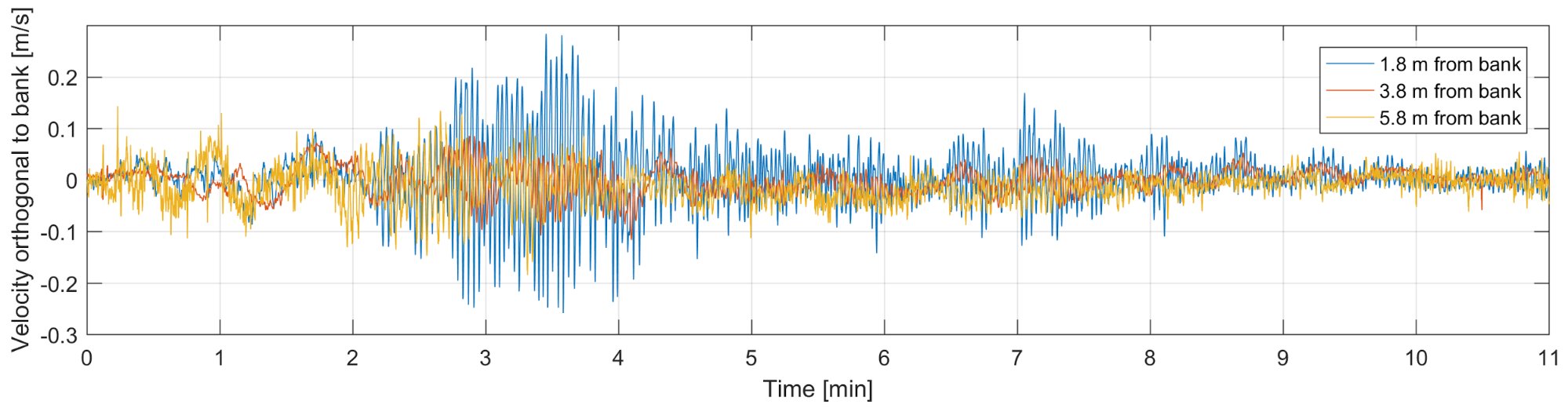
Figure 2. Hydrofoil generated near-bed velocity (orthogonal to bank) time
series at different distances from the bank
Waves propagating towards the bank and breaking in the shallow water areas have also been video recorded with a high resolution camera (GoPro). The novel application of an up-to-date image processing method (Large-scale Particle Image Velocimetry, LSPIV [7]) provides the opportunity to assess wave related velocities on the water surface. The main idea behind the method is to detect and track well recognizable patches on the surface (in this case the foam due to wave breaking) on consecutive frames, and based on the displacements of the patches and elapsed time between the two frames the horizontal velocity distribution on the surface can be derived. The greatest advantage of this method is its applicability in areas where acoustic devices are not applicable i.e. temporarily dry areas.
Based on the gathered field data, computational models are set-up, which means a step towards a better understanding of the related hydrodynamic phenomena. The simulation of the transforming waves due to the topology of the near-bank zone requires up-to-date numerical solutions: high-order discretization schemes and modern free surface capturing methods are obligatory. The model is considered to be validated if the calculated velocities show good agreement with the measured time series for the investigated time period. A validated model can be utilized to simulate conditions for which no measurements are available e.g. impact analysis of planned measures, or flow analysis for water regimes different from the measured ones.
Results
Using the geometric properties of the pressure spectra, different characteristic wave parameters can be derived for the examined time period. Dividing the usually 10-15 minutes long wave events due to a passing vessel to shorter sections (e.g. 1 min) enables to assess the temporal variation of such wave parameters. On the following figures, the temporal alteration of significant wave height and wave period is presented for different ships passed during a field measurement campaign.
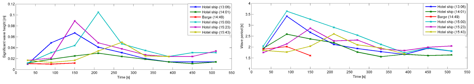
Figure 3. Temporal evolution of significant wave height (left) and wave period (right) due to different vessels
Video records post-processed with LSPIV show the dynamic changes in horizontal velocity distributions in the near-bank area. Using these velocity fields and employing some reasonable simplifications, it is possible to estimate the erosion forces due to wave breaking, i.e. the bottom shear stress, whose relevance had been previously emphasized.
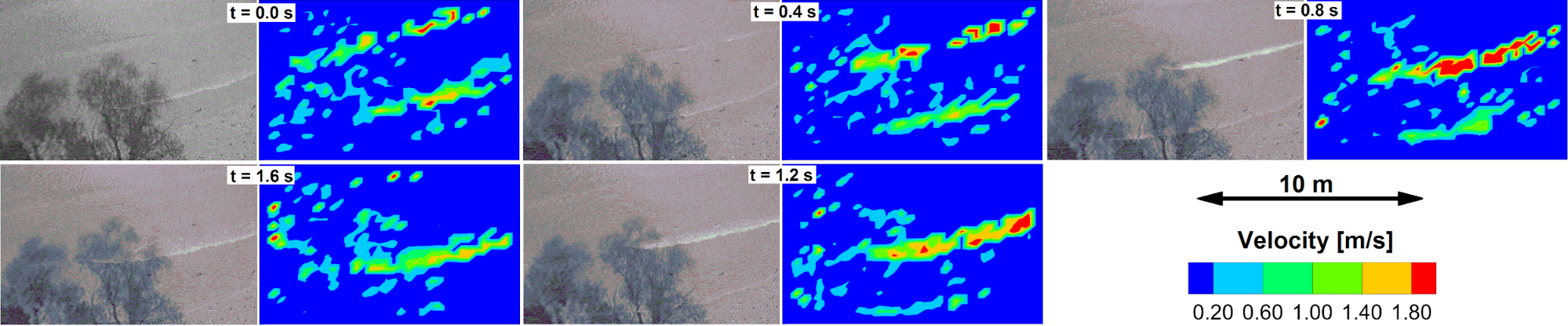
Figure 4. Horizontal distribution of surface velocities, calculated with the
LSPIV method
Computational models of different scales may be set up based on the field measurements. A small-scale model with high spatial resolution makes it possible to numerically investigate the characteristics of the approaching and then breaking waves in a slice perpendicular to the river bank. Fig. 5 presents the phases of wave breaking in consecutive time-instants. It is clear, that such detailed, yet so comprehensive assessment of breaking waves would not be possible with field measurements. Furthermore, the complex free surface due to breaking waves underlines the relevance of up-to-date numerical methods in computational hydrodynamics.
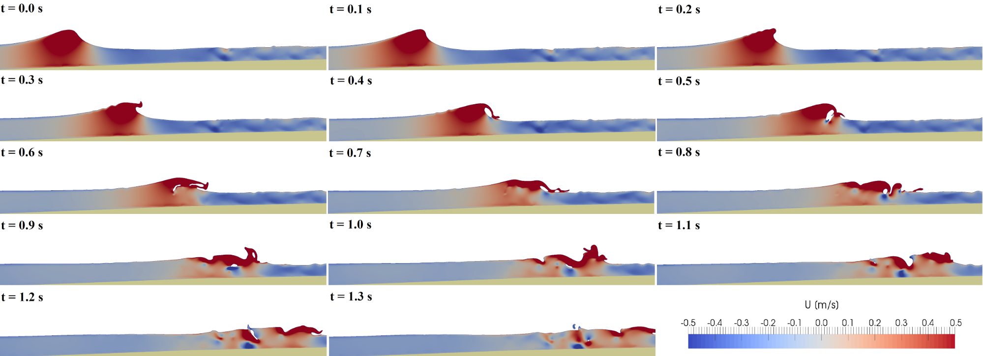
Figure 5. Small-scale model - Numerical simulation of wave breaking
A larger scale model with less fine resolution can contribute, for instance, to the impact analysis of different river engineering measures e.g. the construction of an artificial gravel bar to reduce the harmful effects of ship waves in the near-bank region, so its effect on riverine habitats can be quantitatively assessed.
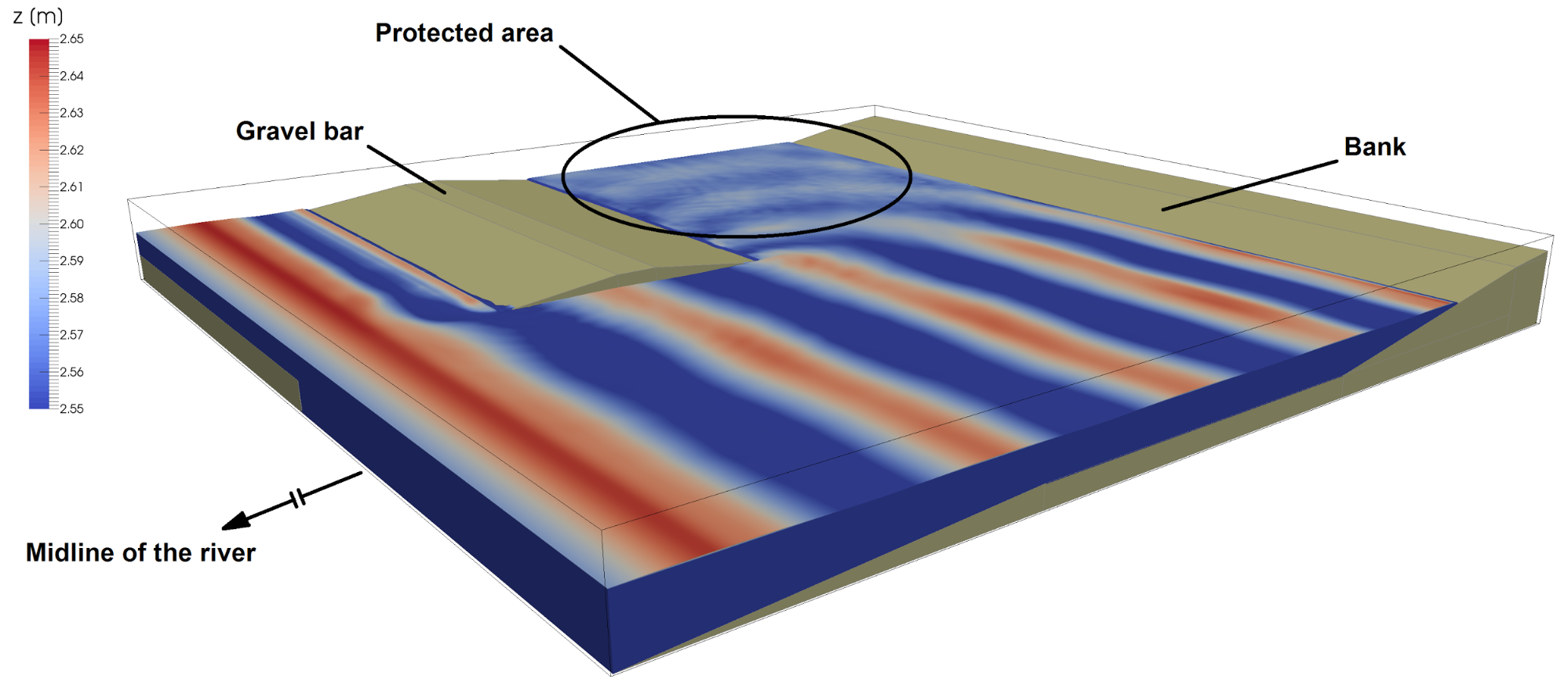
Figure 6. Large-scale model - Three-dimensional simulation of waves around an
artificial gravel bar
Expected impact and further research
In the present state of the research, we have already established the suitable field, post-processing and computational modeling methods for the investigation of different effects of ship induced waves. As a result of a hopefully successful collaboration with biologists and ecologists (e.g. performing joint field measurements) new scientific results are foreseen in the closer future in the field of fluvial ecohydraulics.
The final outcome of the research is to develop and apply a comprehensive methodology to quantitatively reveal the ecohydraulic effects of waves due to ships of different speed, size or other geometric properties. As a result, with the consideration of economic interests as well, environmental protection purposed speed limitations could be imposed for critical river reaches, which in the long term could contribute to the improvement of riverine ecosystems and biodiversity.
Publications, references
Related own publications:
Fleit G., Baranya S., Török G. T., Józsa J. (2015): Élőhely szempontú folyószabályozás megalapozása korszerű hidromorfológiai adatelemzéssel. Hidrológiai Közlöny 95(5-6):22-25.
Fleit G., Baranya S., Krámer T., Józsa J. (2015): Hajók keltette hullámzás hatásának terepi feltárása a litorális zónában. Hidrológiai Közlöny 95(3):29-36.
Fleit G., Baranya S., Rühter N., Bihs H., Krámer T., Józsa J. (2016): Investigation of the Effects of Ship Induced Waves on the Littoral Zone with Field Measurements and CFD Modeling. WATER 8:(7) Paper 300. p 1.
Fleit G. (2017): Élőhelyhidraulikai vizsgálatok a Dunán: Tudomány a sodrásban. Élet és Tudomány 72(11): pp. 326–328.
Tóth B., Sevcsik A., Baranya S., Fleit G., Józsa J. (2015): Élőhely-átalakítás tervezése a Dunán (1776 fkm) - hullámzástól védett parti zóna kialakítása két sarkantyú térségében. Conference poster, XI. Magyar Haltani Konferencia, Debrecen, Hungary, 26-27 June, 2015.
Reference list:
[1] Bulte G., Carriere M.A., Bluin-Demers G. (2010): Impact of recreational power boating on two populations of northern map turtles (Graptemys geographica). Aquat. Conserv.-Mar. Freshw. Ecosyst, 20, pp. 31–38.
[2] Jackivic T.P., Kuzminsk L.N. (1973): Effects of Interaction of Outboard Motors with Aquatic Environment—Review. Environ. Res., 6, pp. 436–454.
[3] Gabel F. (2012): Impacts of Ship-Induced Waves on Benthic Macroinvertebrates. Ph.D. Thesis, Landwirtschaftlich-Gärtnerischen Fakultät der Humboldt-Universität zu Berlin, Berlin, Germany, 2012.
[4] Liedermann M., Tritthart M., Hoyer H., Schludermann E., Keckeis H., Habersack, H. (2009): Effects of vessel-induced waves on different bank types and their impact on the 0+ fish fauna. In Proceedings of the 7th International Symposium on Ecohydraulics & 8th International Conference on Hydroinformatics, Concepcion, Chile, 12–16 January 2009.
[5] Liedermann M., Tritthart M., Gmeiner P., Hinterleitner M., Schludermann E., Keckeis H., Habersack H. (2014): Typification of vessel-induced waves and their interaction with different bank types, including management implications for river restoration projects. Hydrobiologia 729, pp. 17–31.
[6] Bihs H., Kamath A., Alagan Chella M., Aggarwal A., Arntsen Ø.A. (2016): A New Level Set Numerical Wave Tank with Improved Density Interpolation for Complex Wave Hydrodynamics, Computers & Fluids, Vol. 140, pp. 191–208.
[7] Muste M., Fujita I., Hauet A. (2008): Large-scale particle image velocimetry for measurements in riverine environments, Water Resour. Res., 44, W00D19.